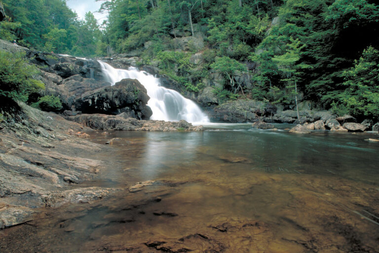
Jacks River Falls is a 60-foot waterfall on the Jacks River in the Cohutta Wilderness of Fannin County, Georgia, where the river drops in two steps through a rocky gorge into deep pools. It sits at the end of a 9-mile round-trip hike, and the area around it is managed under special rules because of heavy use.
The falls
Lidar data estimates the total drop at about 60 feet in two drops, though rendering does not separate the height of each. Broad whitewater cascades span 80 to 100 feet wide in the gorge, with deep pools below.
Getting there
The usual approach is the Beech Bottom Trail from the Beech Bottom trailhead (34.990550, -84.587550), reached on gravel forest roads, with free parking. The hike is 9 miles round trip and is rated relatively moderate. The trail crosses a small creek at about 1 mile and Beech Creek at 3.3 miles; at 3.9 miles it turns west onto the Jacks River Trail, crossing Beech Creek again at 4.35 miles. It does not ford the Jacks River itself. Blazes are sporadic, so carry a map, compass or GPS. Dally Gap is a separate, longer approach; the full Jacks River Trail runs 15.7 miles and fords the river at least 40 times.
Special rules cover the Jacks River Falls Area: except from November 1 through March 31, visitors may not be there between sundown and sunrise. Camping is prohibited except at designated Beech Bottom sites from November 1 through March 31. Fires and stoves, alcohol, and bottles and cans are banned year-round.
When to go
Mountain laurel and wild roses grow along the trail in late spring, with autumn color reflected in the pools in fall. Beech Bottom is the driest route, a plus in cool weather. Avoid the falls after heavy rain.
On site
A heavily used, extremely steep side trail drops to the rocky base. Slick rocks and fast water make the pools dangerous; avoid climbing, swimming near or jumping from the falls. Leashed dogs are allowed. In April 2018, three adults and four children went missing while hiking near the falls; a Georgia DNR helicopter found them at Rice Camp.
History and name
Heavy use and bear encounters led the Forest Service to close Beech Bottom temporarily in the spring and summer of 2000. Stone stacks along the trail may be Native American graves.
Nearby
Jigger Creek Falls is about 4.2 miles away, Panther Creek Falls about 5.4 miles and South Fork Jacks Falls, on the river's South Fork, about 7.8 miles. McCaysville is the nearest town, about 11.4 miles away.
Distances are straight-line.