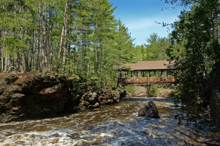
Amnicon Falls is a pair of waterfalls on the Amnicon River in Amnicon Falls State Park, Douglas County, Wisconsin, about 7 miles east of Superior. Its 20-foot upper fall and 10-foot lower fall can be seen from a covered footbridge, formed where the Douglas Fault crosses the bedrock.
The falls
Lidar measurements place Upper Amnicon Falls as a 20-foot plunge and Lower Amnicon Falls as a 10-foot steep sliding cascade, about 175 feet apart on the river's central channel. Earlier surveys listed a 30-foot drop. The river splits into three channels here, with four named falls, so no single fall carries the whole river.
The two falls cross different rock: the upper fall pours over dark basalt from lava flows about a billion years old, while the lower fall runs over layered Lake Superior sandstone. About 500 million years ago the Douglas Fault cracked the bedrock and pushed the south side upward, creating the break the falls now cross. Glacial meltwater swirling sand and stones wore potholes into the basalt, and they hold water when the river is low.
Getting there
The park entrance is at 4279 South County Highway U, South Range, and the park is open year-round from 6 a.m. to 11 p.m. A vehicle admission pass is required: $13 a day or $28 a year for Wisconsin vehicles, $16 or $50 for out-of-state vehicles, and $3 or $13 for Wisconsin residents 65 and older. The 0.25-mile Island Trail reaches Upper, Lower and Snake Pit falls, with another 0.5 mile of relatively flat, easy walking along the river. The campground is closed through May 27, 2027 for road work.
When to go
Water levels and flows change from day to day. Winter hiking and snowshoeing are allowed, though the 1.5-mile snowshoe trail is closed until further notice.
On site
The falls can be seen from the covered footbridge, from trails along the river, or, for the sure-footed, from the rocky shore. Swimming and wading are allowed, though park rules urge caution: rocks are slippery, depths and currents change, and there are hidden rocks. Jumping or diving from the rock walls is prohibited, and children need close supervision. The Thimbleberry Nature Trail offers easy access to the river bed about 0.2 mile downstream of the falls.
History and name
James Bardon bought land here in 1886, and brownstone was quarried beside the river from 1887; a pond on the Thimbleberry Nature Trail fills an old quarry. Douglas County created Bardon Park in 1932, and after land transfers from the county in 1961 and the Town of Amnicon in 1965, the state park now covers 828 acres.
Nearby
Snake Pit Falls is about 0.3 mile away, reached by the same Island Trail. Copper Creek Falls is about 10.7 miles away, and Big Manitou Falls and Little Manitou Falls are about 12.1 and 12.8 miles away.
Distances are straight-line.