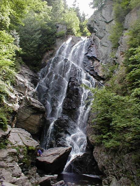
Angel Falls is a tiered waterfall on Mountain Brook in Township D, Franklin County, Maine, where the brook drops 370 feet in a chain of cascades that ends in a 99-foot veil in a cliff-walled gorge. A short, easy trail near Houghton leads to the base of the final fall.
The falls
Three tiers were confirmed by a drone survey in January 2026. The upper one is a sliding cascade of about 175 feet with a vertical step halfway down; after a small pool, the second tier falls about 75 feet sideways into a narrow trough, which ends at the lip of the 99-foot veiling fall seen from the trail. The cascades above can't be seen from the base. Most guides give 90 feet for the visible fall, and cliffs beside it reach 115 feet. Thick beds of quartzite in the Rangeley Formation hold up the falls.
Getting there
Head north on Route 17 from Mexico for about 17.5 miles, roughly 4 miles past Coos Canyon in Byron, then left onto Houghton Road, across the Swift River and right onto Bemis Road for 3.4 miles. These are logging roads: low-clearance cars may struggle, four-wheel drive may be needed, and logging trucks have the right of way. The red-blazed trail drops past an old gravel pit, crosses Berdeen Stream at 0.3 miles and rock-hops Mountain Brook before reaching the falls at 0.7 miles. The round trip is 1.1 miles with 200 feet of gain, no fee and dogs allowed. A trail user reported the access road closed in July 2024, and hikers note the gate is sometimes shut after washouts, which adds a road walk.
When to go
Late May to early July has the strongest flow; the brook runs low by October. The lot fills on weekends and the steep parking road makes winter access hard.
On site
The crossings are slippery and can be dangerous or impassable in high water; one hiker found them waist deep after heavy rain. Swimming isn't possible at the base. Don't climb beside the falls: in July 2022 a 17-year-old fell 40 feet on the right side when a rock came loose, and rescuers carried her out half a mile on a litter.
History and name
The name comes from the shape of the water: at the right flow, the falling water resembles an angel with spread wings.
Nearby
Coos Canyon on the Swift River is about 5.7 miles away, Silver Ripple Cascade about 6.8 miles and Smalls Falls on the Sandy River about 10.8 miles.
Distances are straight-line.