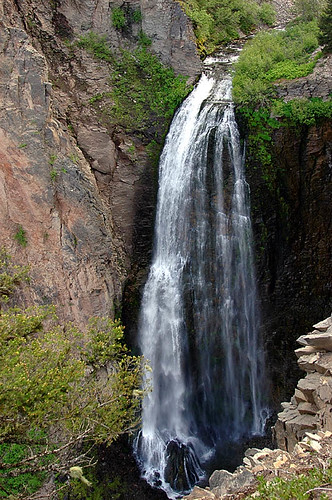
Clear Creek Falls is a 240-foot waterfall on Clear Creek in Yakima County, Washington, where the creek pours off a cliff into a rocky canyon just east of White Pass. Fenced viewpoints along the canyon rim sit a short walk from a signed pullout on US 12, a stop on the White Pass Scenic Byway.
The falls
Clear Creek, which drains a lake above, leaves the rim in a single near-vertical drop about 50 feet wide, spreading into a horsetail as it falls. Field surveys measure the height at 240 feet; earlier surveys listed 228 feet. The cliff consists of hornblende andesite from Deer Lake Mountain, and frost wedging, water freezing and thawing in cracks, keeps splitting the canyon walls.
Getting there
The signed overlook is on US 12 about 2.5 miles east of White Pass, with restrooms at the parking area. From there, visitors can walk downstream along the canyon rim to any of several fenced vistas, including a viewpoint about 200 feet below the restrooms. A second pullout lies about 0.75 mile farther east on the highway.
When to go
The best flow occurs from April to July. For about four months a year the creek runs low, sinking under boulders and vanishing from view for several hundred yards. Overcast days are recommended for photographing the falls.
On site
Accessible restrooms and several accessible viewpoints were built when the site was redeveloped in 2007, though the viewpoint about 200 feet below the restrooms is not accessible. An interpretive trail runs along the cliff tops, with signs about the peregrine falcons that nest in the surrounding cliffs; visitors should stay behind the fences, since the rim drops straight into the canyon. Beargrass blooms along the rim in season. No route to the base is documented.
Nearby
Upper Clear Creek Falls is about 0.1 mile upstream, Devils Maw Falls about 1.3 miles and South Clear Creek Falls about 1.4 miles. The Clear Lake Recreation Area, about 4 miles farther east along the byway, has a boat launch, picnic areas and birding trails.
Distances are straight-line.